My first walk was up Snowdon. I set out from the Pen-y-Pass car park (359m) and headed up the Pyg Track. The path soon gains height and before long I was up above the Miners Track looking down at Llyn Llydaw. The path leveled out here, and a bit further on just beyond Glaslyn the Miners Rack climbed up to meet the Pyg Track which I was on. At the point I was at about 700m (100m above Glaslyn) with about 300m to climb to reach the Railway Track from Llanberis. In a number of places the path was difficult to follow and clambering over the slippery rocks was a challenge. After a steep final burst I reached the ridge which follows the Railway Track to summit. Although the path was fairly easy going from here, a bitingly cold wind was blowing the rain at me from the right with no shelter.

After 1 hour 45 minutes I reached the summit at 1,085m, here I had a brief rest to admire my achievement before heading down out of the wind. (Unfortunately the summit cafe was closed for refurbishment so their was nowhere to shelter at the top).
I made my way back down - a slow process over the steep wet rocks. By the time I reached the point that the Miners Track leaves the Pyg Track the weather had started to clear. When I got to Glaslyn the sun had come out so I stopped for a lunch break. I was finally able to get some good views of Snowdon.

Snowdon from Glaslyn @ 605m - 480m to the summit.
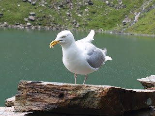
As it had been raining all the way up I had not seen any birds. I had heard a few Meadow Pipits around though. Whilst having lunch a couple of Herring Gulls gave some good photo opportunities. I also managed to see a pair of Ravens heading to the rocks towards the top of Snowdon.

Herring Gull at Glaslyn

Herring Gull at Glaslyn
Following the Miners Track back down to the car park, more Meadow Pipits were seen and a brief glimpse of a Wheatear. Total height climbed 726m.
Cadair Idris
The walk for Day 2 was up Cadair Idris near Dolgellau, which stands at 895m. I decided to start the walk from Penmaenpool on the Mawddach. I would therefore be climbing the whole 895m from sea level.
My route up Cadair Idris (Purple) and back (Green)
Several Grey Wagtails were seen in the Abergwynant river and a Dipper was seen just before the Youth Hostel.
On the mountain itself there were a few Meadow Pipits and a couple of Wheatears.
On the way back to Penmaenpool as the path leaves the road alongside the Abergwynant river it rises steeply through a bracken covered moorland and eventually passes back down through green fields to the village. Up at the top of the hill a Peregrine was seen swooping on prey of some kind, which it then took off into a tree. A Buzzard was soaring overhead.
The final descent is along a gravel track through woodland to Penmaenpool.
Map images produced from the Ordnance Survey Get-a-map service. Images reproduced with kind permission of Ordnance Survey and Ordnance Survey of Northern Ireland.


